Welcome to Pend Oreille County Park, a little known, overlooked hiking and camping area. In the early 1980’s the State of Washington granted jurisdiction of this park to Pend Oreille County. Its 440 acres has over 7 miles of dirt trails in an old growth forest setting. Major use of the trails is by hiking and horseback. Whether you are planning a family picnic, hiking with friends or just craving some solitude in a magnificent setting, Pend Oreille County’s park and trails can provide a great outdoor experience. The trail system may be accessed year-round for hiking, horseback riding, snow-shoeing and cross country skiing from the park entrance parking lot. The trails are maintained by volunteers. Please contact the Parks and Recreation Department if there are issues to be corrected on the trail.
The park has a front area with a parking lot, an ADA accessible vault toilet, two interpretive signs, and a large park sign. Beyond the gate is a primitive tent and small RV campground (no hookups), a day-use picnic area, and an extensive trail system. Wildlife such as elk, white-tailed deer, moose, bobcat, bear, and many small mammals as well as bird species are abundant in the park but the main attractions are the majestic old growth trees found in the area.
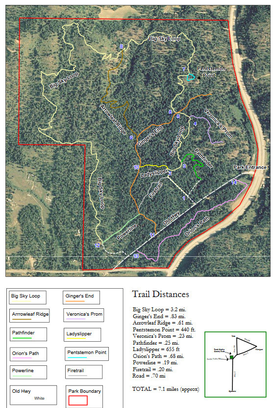
These over 7 miles of trails throughout the park consist of one main loop trail and a variety of adjoining trails and loops. Each trail section has a creative name that adds charm to the park. Names include Big Sky Loop, Pathfinder, Veronica's Prom, Pentstemon Point, Arrowleaf Ridge, Ginger's End, Powerline, Ladyslipper, Firetrail and Orion's Path. The largest loop possible in the park follows three of the named trail sections: Pathfinder, Big Sky Loop and Orion's Path. There are a number of shorter loops as well as out-and-back hike options. This full loop takes in most of the best views in the park. Most of the trail is heavily forested, so there are not many open, panoramic views. This is a good place to come on a hot day because there is very little sun exposure.
The park map has an intuitive route system where each intersection is numbered. If you lose your way, hike until you encounter a trail intersection with a numbered marker to find your location on the park trail map. Approximate locations of the numbered intersections have been added on the map as waypoints for convenience.
Before you go, you may want to visit the Pend Oreille county website and print a hard copy of the trail system, as on-site signage is poor. Currently, it can be a little confusing on the trails. Pend Oreille County was supposed to re-map the trails and proper signage was to be installed by Spring 2020. I am not sure how that went, with Covid19 delaying and cancelling many dept. projects. Many trails are very overgrown, which can lead to mild frustration. Trust the map and push through the short sections of head-to-toe thickets to continue. There are a few true dead ends in the trail system, so be aware of where those occur. In addition to trails indicated on the park map, there are at least two other significant sections not mapped. You will know the unofficial trails by their lack of numeric markers at the intersections.
Day Use Area (No Parking or Access Fee)
Amenities include:
Medium sized open picnic shelter
Picnic Tables
Fire rings
BBQ grills
ADA Compatible Vault toilet
Large parking lot that will easily accommodate 20-25 vehicles
Parking lot is large enough to accommodate school buses.
Camping
The campground includes one single vault ADA accessible toilet, freeze proof water hydrant, 26 campsites (most with fire rings and picnic tables), and a self-service pay station which costs $10.00/night. Camping is allowed from May (day varies) to November 30, depending on the weather, and is available on a first come, first served basis. There is no electrical nor water hookups, and no RV dump station. Camp sites are limited to vehicles 18′ in length or smaller. Larger vehicles can park in the Day Use Area parking lot.
The front parking lot is open year-round and will accommodate around 8 cars. You can walk in and hike any time of the year.
The gate is open from 7:30 a.m. to 7:30 p.m. May to Labor Day, and from dawn to dusk from Labor Day to November 30 (depending on the weather). The gate is closed from Dec 1 to April 30th. The campground is open from May to Novembr 30, depending on the weather. "Depending on weather" means that if it snows, the gate will not be opened, because the road is not plowed when it snows. If you have any questions about times of service, call the County Public Works Dept at: (509) 447-4821.
The cache is placed on "Orion's Path". There are coordinates below for the place where you turn onto this path. Follow the path until you are about 40' from the cache. There is another cache on this trail, so don't forget to find that one, too! FTF prize is a head lamp. I couldn't fit all the swag in the cache, so there is a bag outside the cache also. Take your pick!
Pend Oreille Country Park Trails1

Pend Oreille Country Park Trails2

Pend Oreille Country Park Trails3
MY OTHER HIKING CACHES:
Priest Lake
Priest Lake2
English Point
Hawk Hill
Farragut State Park
Antoine Peak
Liberty Lake
Missile Site
McKenzie
Iller Creek/Rocks of Sharon
Dishman Hills
Palisades Park
Round Lake
Slavin
Wolf Trails
Rathdrum Mountain