Kachina Prairie Park
This park is rich with geological history.
Answer the following questions and then send me a message to get credit for this Earthcache.
This park used to also be rich with geocache varieties. Maybe it will be again one day?
(When placed, there was this earthcache, a traditional, a multi, and a mystery)
Some notes before starting...
- There is a trail that goes around the park and will get you close to the locations for this earthcache. While convenient, you are not making observations about the trail. So be sure to take a few steps off the trail to make your observations.
- This trail is not wheelchair accessible in rain or muddy weather. This trail is not paved but it is fairly flat so it may be possible to complete in dry weather. Use at your own discretion.
- All the info you need is on the cache page or at the location.
(Bibliographic sources are attached as an image here.)
Logging Requirements
- As recently as how many years ago was Ellis County at the bottom of the sea?
- What was the name of the smaller seaway that existed as the Western Interior Seaway retreated south and the land dried out?
- What two landscape formations were the result of this inland sea?
- At Reference point #1, What kind of landscape features do you observe? Is it sandy or rocky or a combo? Is it part of the seafloor or sandy ridge? What is the elevation reading?
- At Reference point #2, What kind of landscape features do you observe? Is it sandy or rocky or a combo? Is it part of the seafloor or sandy ridge? What is the elevation reading?
- At Reference point #3, What kind of landscape features do you observe? Is it sandy or rocky or a combo? Is it part of the seafloor or sandy ridge? What is the elevation reading?
- Make a note of the highest and lowest elevations. Why do you think there is this difference?
- Optional: Pictures are welcome but not required.
Western Inland Sea
In the recent past (geologically speaking) this area was under water. In the Late Cretaceous Period 80-118 million years ago, warmer climate influenced from the Late Jurassic/Early Cretaceous resulted in drastic sea level rise, creating many inland seas. In North America, the colliding of the Kula and Farallon tectonic plates with the North American tectonic plate created an opening in the Arctic Ocean and the Gulf Of Mexico for seawater to travel through, and splitting North America into three(3) separate land masses.
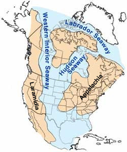
The Western Interior Seaway lasted about 60 million years and is estimated to be completely gone about 70 million years ago. While the Kula and Farallon plates subducted beneath the North American plate, multiple hills and mountains slowly began to form, helping to create the basis for modern landscapes.
At the end of the Cretaceous, a continuing uplift in a mountain-building episode called the Laramide orogeny hoisted the sandbanks (sandstone) and muddy brackish lagoons (shale) – the thick sequences of silt and sandstone still seen today as the Laramie Formation – while low-lying basins between them gradually subsided. The Western Interior Seaway divided across the Dakotas and retreated south towards the Gulf of Mexico. This shrunken, regressive phase of the Western Interior Seaway is sometimes called the Pierre Seaway.
As it retreated south into the Gulf of Mexico, rich mud and clay accumulated on the flat sea bottom while sandy beaches formed around the shores. The retreating water deposited sediments on the old seafloor. As the land dried, these sediments remained forming the diverse eco regions of Texas. This specific area of Texas is classified as the Blackland Prairies region and is named for the deep, fertile black soils that characterize the area. These deposited sediments and the rich soil has given this area some of the richest farm land in the state. Crop production and cattle ranching are the primary agricultural industries. The landscape is gently rolling to nearly level, and elevations range from 300 to 800 feet above sea level.
The sand which had accumulated along the shore of the ancient seaway was preserved as a sandy ridge riding above the flat water plane. These features called “Lake Ridges” indicate that the Western Inland Seaway surface may have once been nearly a hundred feet higher than this area's present elevation. The sandy beach deposits rising above the nearly flat plains of north Texas, captured the attention of Indian and European explorers and settlers because the ridges provided dry passage through the swamps produced on the former lake beds. One notable example is the Flower Mound hill located in Flower Mound, Texas some 60miles northwest. The Indian trails along the beach ridges were succeeded by primitive roads, stage coach routes, and later by paved highways. Much of this sand has been removed for use in construction or to flatten the land for agriculture.
Kachina Park contains remnants of both the ancient sea bed and the ancient beach. The hill at the center of the park is an example of one such sandy ridge. It is surrounded by flat agricultural plains which are the remnants of the old seafloor bed.
Summary
To complete this Earthcache, go to the various reference points and take some measurements.
- For the hill, you will need to evaluate the landscape here and determine if you believe this to be part of the sandy ridge. Look at the soil to the south off of the trail for the best results. (Is it rocky, sandy, or some combo??) Also take an elevation reading at this location.
- Next go to the lake at the northern end of this park. This can be reached by the mowed path around the park. Get as close to the shore as possible for the best results. Make observations about the landscape to determine if it is part of the sandy ridge or a remnant of the seafloor. (Is it rocky, dirt, sandy, or some combo?) Also take an elevation reading at the location.
- Lastly go to the southern end of the park and look at the shore area. The mowed path will get you close but you will have to exit the path to get to the location. Get as close to the shore as possible for the best results. Here you need to evaluate the landscape to determine if this spot is part of the sandy ridge or a remnant of the seafloor. (Is it rocky, dirt, sandy, or some combo?) Also take an elevation reading.
- You now should have all of the information required to complete the questions above.
Congratulations winkys
for the First to Find approximately 21 hours and 39 minutes after it published. Congrats!
To get credit for this cache, send me a message with your answers to the questions, and your observations of the locations. Please include your error correction... (+/- what accuracy for elevation readings your gps/phone depicts).
Using my profile, send me a message with your answers. Do not post them with your log!
You do not have to wait for me to respond to log your find. But if I do not receive a message from you with the answers, I will delete your log without notice. If you are in a group, only one member needs to email me the answers, as long as the message says which people are with the team. (List the team members since I do not know who was with you and only part of your usual team may be present.) I will contact you if your answers need extra work.
Any Lognotes with answers will be deleted. Please do not post your answers in your log.
You need to actually visit the location and make observations. No Arm Chair Logging. Logs that indicate otherwise will be deleted.
Do not post your answers in your log.