Part of a series of multi's designed to help you explore some Christchurch suburbs. I'm working from the suburb boundaries in Google Maps, which I've come across in a number of other places.
Strowan
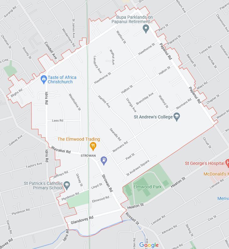 Map Data ©2021 (image from Google Maps)
Neighbouring suburbs: Bryndwr, Papanui, St Albans, Merivale, Fendalton.
Name origin: Named after the (large) Strowan property on Papanui Road (now the site of St Andrew's College).
Papanui Road is the north east boundary of Strowan. The road was built soon after Christchurch was established in 1850, to connect the new town centre to one of the few stands of nearby timber in Papanui. To take the road over the Avon river, Papanui Bridge was built in 1852. It lasted a little over 10 years before it was replaced in 1864, and renamed Victoria bridge. The timber in Papanui Bush lasted until 1857. The property that became Strowan was established in the 1850s by Sir Thomas Tancred on Papanui Rd. The property was later sold to Thomas Smith Duncan, who named it Strowan after his brother-in-law's estate in Perthshire, Scotland.
By the early 20th century the suburb of Strowan was on the outskirts of the city, and some big houses were being built in the suburb (the houses near WP4 include a number of substantial houses that date from the first decades of the 20th century). In 1917 St Andrew's College was founded, and the same year Strowan was purchased and became the site of the new school. Strowan House still exists and can be seen from WP1 (it is the two story wooden building to the right of the brick building directly across from the gates). The other school in the suburb is Waimairi School, a primary school that opened as Blairs Road School in 1914. The suburb of Strowan is largely residential, with a small shopping centre around the Strowan Rd / Normans Rd intersection.
Looking at the map, the route of the Main North Rail line is easy to see, and runs pretty much North/South through Strowan. This part of the line was laid in the 1870s; well before the suburb was developed. One of the few pedestrian rail overbridges in Christchurch (WP2) gives access to Waimairi School. The one station on this section of line (Bryndwr station) was just north of the rail crossing where Strowan Road turns into Wairakei Road. The station closed in 1977. The station building is still there (WP3), but for some reason the name on the sign is not what the station used to be called.
The only park of any size in the suburb is Plynlimon Park (elsewhere in the suburb two walkways lead to Elmwood Park from St Andrew's Square (WP4), and a lot of the grounds of St Andrew's College is green space). Plynlimon Park (WP5) was named after Plynlimon Road, which was named after the highest peak of the (Welsh) Cambrian mountains (one of a number of Welsh street names in the Bryndwr area). The park was created in the mid 1950s on what had once been a gravel pit and then a rubbish dump.
In terms of streams in the area, the Wairarapa Stream is the boundary for the southernmost part of Strowan (WP6). Also, St Albans Creek has its source in the grounds of St Andrew's College.
You will need to visit six waypoints to work out where the cache is hidden.
Final: S 43 30.A(H+J)(C+K+L) E 172 36.GE(B+D).
- A = number of light coloured bands in the brick gate posts (count the bands in both posts, and count each cap as a band) at WP1 (St Andrew's College gate).
- B.CDE = distance in km on signs at WP2 (Rail overbridge).
- FG = position in the alphabet of the third letter on the sign at WP3 (Bryndwr railway station).
- H = number of main trunks the middle tree in the row of 7 splits into just above head height at WP4 (walkway to Elmwood Park).
- J = number of metal bars (that were once completely covered in blue paint) that make up a ladder at WP5 (Plynlimon Park). Note the number is odd (just in case the bottom one is covered by bark).
- KL = number of sleepers that sit on the metal girders of the bridge, and support the rails at WP6 (Railway bridge).
Checksum of A to L: 41 (A to L are all single digit numbers).
Cache is a pill bottle hidden inside a block of wood. It's on top of the bottom fence rail behind a distinctive fence post (the block of wood should be easy to spot!).