MONUMENTALIST! (Bucks)
To celebrate my first/third year of setting caches (MONUMENTAL! was number 38 since I started with my Chess themed Geocache No.1 - Black Rook on July 1st 2003, and this is number 129, including some adopted ones) I decided to re/place one at one of my favourite locations in Bucks. I saw in the new millennium (both of them!) up here and returning always brings back some great memories for me. After MONUMENTAL! was found in the open, I've moved it to a whole new location with fresh challenges and as it can be relogged by past finders, I've made a whole new cache of it. I hope you'll enjoy the location (again?)
This was also the focus for GC25F7B 10 Years! Coombe Hill, Bucks, UK - an event to celebrate 10 years of caching, held on a windy Sunday; May the 2nd 2010.
Unless you fancy a monumental climb, I suggest you park for free near the top of the hill around N51° 44.912 / W000° 46.065 but be sure to hide your valuables! Sadly this is a spot popular with thieves.
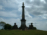
Take a walk to N51° 45.178 / W000° 46.293 where you'll find a very dramatic monument and a full set of views across Oxfordshire, Buckinghamshire and Hertfordshire. In the immediate vicinity of this Boer War monument you'll also find the answers to the following questions:
- How far is it to Brill Hill? Answer 13 miles, 58B feet
- The monument was almost totally destroyed by lightning in which year? Answer 19E8
- In which year was the monument's bronze tablet replaced with a stone one after the original was stolen? Answer 19D2
- How far away is Pulpit Hill? Answer 8C6 feet
- How high is this hill? Answer 85A feet.
The Cache is located at:
N51° 45.ABC / W000° 46.ADE
While you're cursing me, think how much more evil I could have been. Anyway, happy hunting!
Oh, and don't forget to do the cache linked at the top of this page. It's only a few hundred feet away from the monument!

Read more about The Historic Geocaches' campaign.
THE GEOLYMPIX RETURNS! With a Winter twist! GC75FTF - Saturday October 27th 2018 - Ashridge Estate, Berkhamsted, Herts, UK