Formation of Mill Creek Canyon
Either print the images on this page or be sure you have them offline on your phone so you can refer to them onsite.
Logging Requirements
Before following the instructions in the questions, read the information on the cache page. The questions are likely to make more sense. They are just at the top of the page to save you scrolling when on site.
- Using the map of deposits with the deposits legend below, what kind of rock would you expect to be standing on at the posted coordinates? (Hint: Are you standing in a blue or dark purple area?)
- Closely examine the rocks within 50 feet of the posted coordinates.
- What color are they?
- Are there fossils or other inclusions in the rock?
- How do your observations verify your expectation based on the map?
- If you were to walk due west from the posted coordinates or any point within 200 feet north of them, would you continue on a trail or fall to your death?
- Using the map of deposits with the topographic legend, what does that tell you about how the rock you are standing on got here? (Did that make you change your answer to Question 1?)
- Looking toward the city, what shape is the canyon?
- Given this shape, was it eroded only by water or also by glaciers?
- Optional: If you have time after your hike and it’s between June 1 and Nov 1 when the gate is normally open, drive to the top of the canyon. Notice the difference in shape. Why isn't the lower part of the canyon like this?
- Optional: Post a picture of your group at the overlook.
Educational Objective
The goal of this Earthcache is to give you the big picture of how Mill Creek Canyon was formed. It will direct you to visual evidence of this formation at the posted coordinates. There were three phases to the formation; 1) sediments from inland seas hardened into rock; 2) movement of the crust along the nearby fault line, and finally, 3) erosion.
Background Information
Deposits from Inland Sea(s)
Well before the formation of Lake Bonneville, this area was at the bottom of an ocean. Think about that for a minute as you stand atop this ridge looking down on a city a couple thousand feet below you.
From as long ago as 700 million years, the start of the Cambian Period, the area we call Utah was covered by shifting waters. Throughout the Paleozoic Era, oceans repeatedly came and went leaving the deposits that form much of the rock on the top of the southern ridge of Mill Creek Canyon.
During the periods the area was covered by inland sea, limestone formed because the seawater has high concentrations of two key dissolved chemicals, calcium (Ca++) and bicarbonate (HCO3-) ions. Many sea creatures use these two chemicals to make protective shells by combining them to form calcite or "aragonite," which is the same chemical composition as calcite but has a different crystal form. When the creatures die leaving their shells on the ocean floor, the shells become part of the sediment. This is why we can often see fossils of these shells in the rock that was formed below the sea.
Subsequent layers of sediment as well as the sea water itself would would create pressure that compressed the lower sediment into rock. As the water evaporates, the sediment can be compressed into increasingly dense rock depending on the available pressure. Once the water evaporates, it no longer keeps the tiny pieces of sediment apart. Also the calcium carbonate released by the evaporating water becomes like glue within the sediment. Together the sediment and calcium carbonate form what we call limestone. There are many different types of limestone depending on the composition of the sediment and concentrations of other minerals in the water. For example, magnesium may convert some or all of the calcite in the limestone to dolomite. The map below shows the areas different types of limestone deposited.
Uplift of the Wasatch Range
After all that depositing and compressing, a crack in the earth's crust, known as a fault, began to move things around. The particular fault of interest here is the Wasatch Fault. The Wasatch Fault is part of the Intermountain Seismic Area. Even though most people speak of the Wasatch Fault as if it were a single fault, it is actually a series of about 25 faults stretching over 240 miles north to south. The are additional smaller fault lines surrounding the main faults.
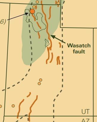
The Wasatch Fault and most of the surrounding faults are normal meaning the part of the crust with the mountains goes up and the part with the valley goes down sliding vertically along each other.
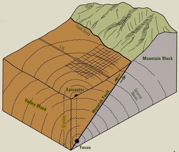
Although the Wasatch fault was likely moving during the time of the inland seas, perhaps even contributing to the drainage of some of the seas, what we are most interested in for the canyon formation is about 3-3.5 million years ago. This time when there was great movement along the fault it caused an uplift that today we call the Wasatch Mountains. When this uplift occurred the crust folded and developed smaller cracks. Not all parts of the the crust were uplifted equidistantly. The folds that went upwards are the peaks and ridges; the folds that went downward we call drainages because precipitation that falls on the higher folds drains down these lower folds. Sprinkled throughout the folds are places where the crust or all those sedimentary layers discussed above cracked or deeper layers of sediment perhaps even some bedrock were thrust higher that the surrounding surface. These are our cliffs, tors, pinnacles, and all the other names we have for rocky extrusions along an otherwise smooth mountainside.
Look around where you are standing. Do you see the evidence of the uplift along a secondary normal fault? Use the map of deposits above and the topographic legend below to help you identify the uplift here.
Erosion
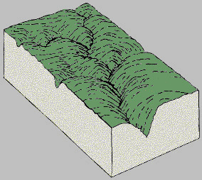
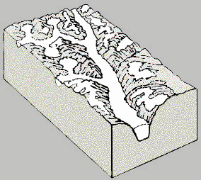
From what we've learned so far it seems like the canyon should have about the same angle near its floor as on its ridges as a result of the folding process, but it doesn't. It's very narrow at the bottom. Here's the thing, over time all that water draining across the downward folds erodes away the softer (compared to the bedrock in the crust) sedimentary layers formed from the inland sea deposits. Where the road is now was several hundred feet below the surface when the Wasatch Range first rose. This erosion process is what gives a canyon a V shape. Some drainages had glaciers form in them during the ice ages. As the glacier flowed down the drainage, it scoured out what the water had done changing the shape to a U.
|
Folds before erosion
|
Folds with erosion
|
More erosion from glaciers
|
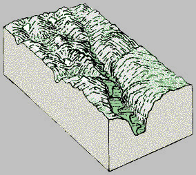
Folds after glaciers
|
In Summary
So there you are. We now have this wonderful canyon to play in as a result of erosion on the folds in the earth's surface caused by movement along the faults under the sedimentary layers formed by the inland seas. Whew! A lot has happened here geologically speaking. I hope this gives you a better understanding of the earth your standing on while you enjoy the great view from this overlook.
References
Bauman, J. (2004, November 29) How did the Wasatch Range raise? Retrieved from https://www.deseretnews.com/article/595108749/How-did-the-Wasatch-Range-rise.html
Bliss, J.D., Hayes, T.S., and Orris, G.J. (2008) Limestone: A crucial and versatile industrial mineral commodity. Retrieved from http://geology.com/usgs/limestone/
Chronic, H. and Chronic, L. (2004). Pages of Stone (2nd Ed.) Seattle: The Mountainers Books.
Geologic guide to the central Wasatch front canyons (n.d.) Retrieved from http://files.geology.utah.gov/geo_guides/c_wasatch/pdf/pi-87.pdf
Glacier carves a U-shaped valley, A (n.d.) Retrieved from https://www.nature.nps.gov/geology/usgsnps/glacier/uvalley.html
Limestone: What is limestone and how is it used? (n.d.) Retrieved from http://geology.com/rocks/limestone.shtml
Milligan, M. R. (n.d.) How was Utah’s topography formed? Retrieved from https://geology.utah.gov/map-pub/survey-notes/glad-you-asked/how-was-utahs-topography-formed/
Wasatch front canyons geologic tour (n.d.) Retrieved from http://utahdnr.maps.arcgis.com/apps/MapTour/index.html?appid=5cf1570b998346d98478a5abd50bf096#map
Wasatch fault, The (n.d.) Retrieved from http://files.geology.utah.gov/online/pdf/pi-40.pdf
Wasatch fault tour signage in Big Cottonwood Canyon