
North Stradbroke Island is one of a series of sand dune mass islands off the South East Queensland, that provide the eastern boundary of Moreton Bay. The island is accessible from the mainland by Ferry either from Cleveland or Redland Bay.
It is the worlds second largest sand island, with Fraser Island to the north the largest. The highest point on the island is Mt Hardgraves at 219m above sea level, part of a series of ancient dunes that run across the island.
Below is the geological map for the island (from Reference 1). 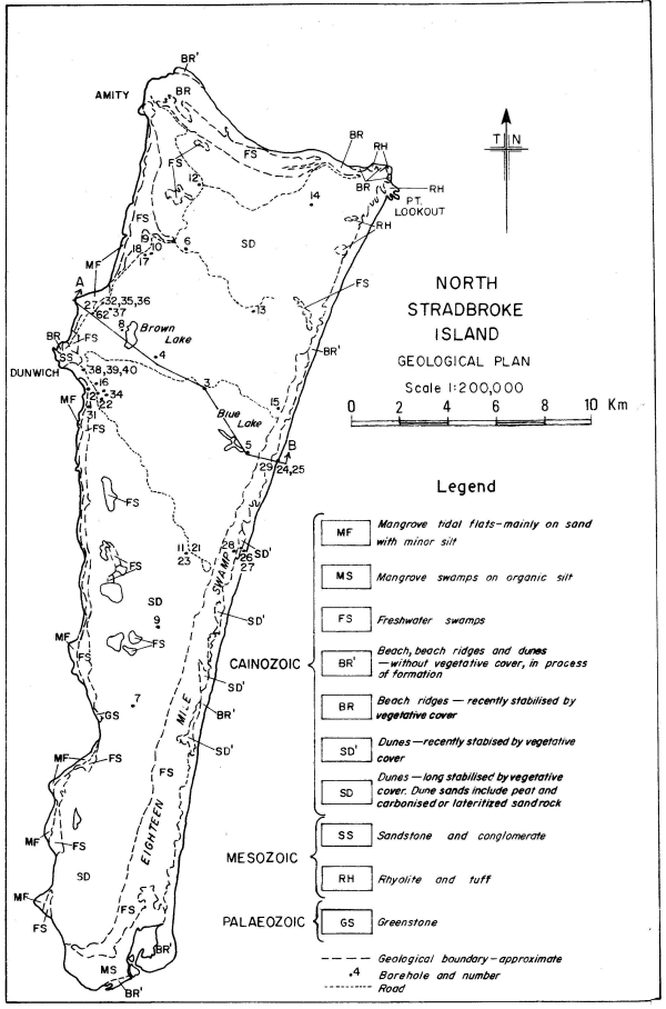
The ancient dunes are trangressive parabolic dunes, formed during glacial times. The dunes were formed during drops in sea levels as a result of a glacial events (when the sea was far out onto the continential shelf), with sand blown in from a predominant south easterly winds. This is based on the alignment of the dunes which appear to be aligned on a north west axis from the coast, and morphological discontinuities in the dunes.
The cainozoic sand is a source of heavy minerals such as rutile, zircon, monazite and ilmenite, and silica sand.
Point Lookout on the north east corner of the island, is dominated by Triassic rhyolite cliffs and sea caves separated by a series of sandy surf beaches. There are also a number of rock outcrops offshore.
Along Canaipa Passage on the western side of the island, there are outcrops of Palaeozoic greenstones, the oldest exposed rock on the island.
To log this cache you need to;
1. Email the owner with the answers to the following questions;
(a) What time period did the volcanic activity occur that formed the Point Lookout headlands?
(b) Why is North Stradbroke Island unique?
2. Take a photo of yourself and/or your GPSr with the Point Lookout beach and headlands in the background (Hint: There is a great view of Frenchman’s Beach nearby)
To log this earthcache, send your answers through Message Board. Feel free to log but if I see no answers I will delete the log. Enjoy!
Nearby. There is plenty to do nearby including cafes and a gelato shop (family favourite) plus the Gorge Walk, whale watching if you are there at the right time of the year, or just take in the views!
References
1. J.W. Laycock “North Stradbroke Island – Geohydrological Report”, Geological Surveys Queensland, 1975.
2. W.T.Ward “Notes on the Origin of North Stradbroke Island”, University of Queensland, 1977.