Pantokrator II EarthCache
-
Difficulty:
-

-
Terrain:
-
Size:  (not chosen)
Please note Use of geocaching.com services is subject to the terms and conditions
in our disclaimer.
Introduction
During our 10-days holiday on Corfu in August 2008 we successfully
found all twelve caches on this island. In addition our wayfaring
led us in fabulous places where no cache is placed. On three of
them we decided to create Earthcaches:
Pantokrator,
Pantokrator II and
Bella Vista to Paleokastritsa. We also highly recommend to
visit by boat
Lake Butrint and Vivari Channel which is not so far.
Enjoy this spectacular countryside!
Geomorphology
Mount Pantokrator (yes, it has the same name as the highest mount
on Corfu island) is a mountain located in the middle of the Corfu
and with its height about 550 metres it is the highest mountain in
this locality. White radar bulb on its top is non-overlooked. Corfu
is one of the islands that are contained to the Ionian zone.
The Ionian zone exhibits three distinct stratigraphic sequences,
representing a pre-rift, a syn-rift, and a post-rift stage of
evolution of the Ionian realm, from a neritic platform environment
to a pelagic basin. Corfu is located near the Kefalonia geological
fault formation and as such earthquakes sometimes are felt. The
whole island, composed as it is of various limestones formations,
presents great diversity of surface, and the views from the more
elevated spots are magnificent.
Pantokrator II
Additional information
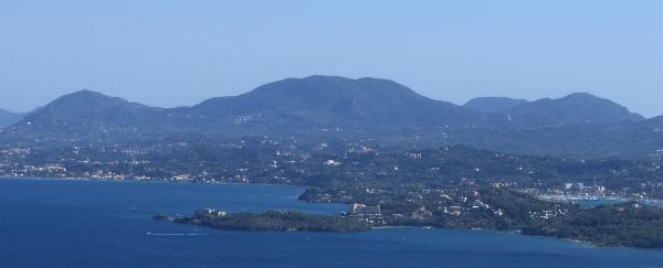
From the top of Pantokrator you can see the largest area of the
island Corfu. You will see the city Corfu (Kerkyra) like on your
palm.
How to get the earthcache coordinates
Earthcache “Pantokrator II” is reachable using car and road from
Agio Deka and Makrata. Drive carefully! The last part of the road
is from a concrete and it is narrow only for one car in both
directions together. Fortunately on this road there is a little
traffic because this mount is not frequently visited by tourists.
Approving the finding
To approve the finding of this Earthcache you need to:
1) Using profile e-mail me in which rift stage Pantokrator
limestones were formed.
2) Geomorphology activities formed Pantokrator II into the mountain
which has more than one peak. Using profile e-mail me how many
peaks it has and how many peaks are accessible using roads or
paths?
3) Using profile e-mail me in which height the Pantokrator II
coordinates N 39° 33.053 E 019° 52.811 are. Please use your GPS at
the given coordinates.
4) Using profile e-mail me the number that is on the yellow table
on the coordinates N 39° 32.994 E 019° 52.874.
5) Using profile e-mail me which white object you see from the
Pantokrator II coordinates N 39° 33.053 E 019° 52.811 in azimuth
215 degrees (approximately south-west) and distance 400
metres.
6) Upload in the log photo from the Pantokrator II coordinates N
39° 33.053 E 019° 52.811 with you and the radar (see spoiler).
Please do not put above mentioned yellow table and white object in
any photo that you uploaded.
Please feel free to log your finding and to send your answers for
approving questions at the same time. If your answer will be
incorrect we will contact you for its correction.
Additional Hints
(Decrypt)
1) hfr vagrearg
2) ybbx ebhaq ng gur pnpur pbbeqvangrf naq vgf arne fheebhaqvatf
3) hfr lbhe TCF ng gur pnpur pbbeqvangrf
4) ybbx ebhaq ng gur fcrpvsvrq pbbeqvangrf (irel pybfr gb gur enqne)
5) ybbx ebhaq va gur fcrpvsvrq qverpgvba ng gur pnpur pbbeqvangrf
6) frr fcbvyre