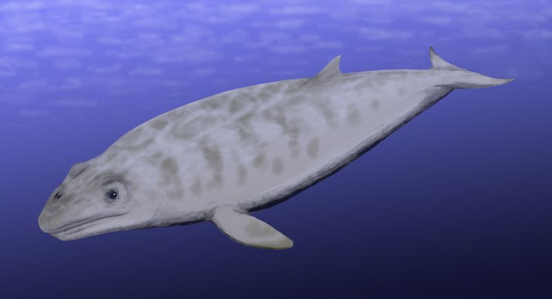
Janjucetus
Janjucetus hunderi, lived during the late Oligocene, about 25 million years ago in coastal seas off southeast Australia. Unlike modern mysticetes, it possessed large teeth for gripping and shredding prey, and lacked baleen. Janjucetus was likely to have been a raptorial predator that captured large single prey animals rather than bulk-feeding on small organisms in the manner of living baleen whales.
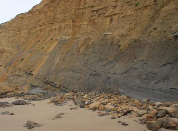
Jan Juc Marl
Marl or marlstone is a calcium carbonate or lime-rich mud or mudstone which contains variable amounts of clays and aragonite.
Marl was originally an old term loosely applied to a variety of materials, most of which occur as loose, earthy deposits consisting chiefly of an intimate mixture of clay and calcium carbonate, formed under freshwater conditions; specifically an earthy substance containing 35-65% clay and 65-35% carbonate. The term is today often used to describe indurated marine deposits and lacustrine(lake) sediments which more accurately should be named marlstone. Marlstone is an indurated rock of about the same composition as marl, more correctly called an earthy or impure argillaceous limestone. It has a blocky sub conchoidal fracture, and is less fissile than shale. The term marl is widely used in English-language geology, while the terms Mergel and Seekreide (German for "lake chalk") are used in European references.
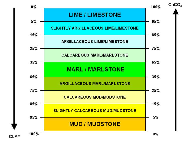
Scheme of the transitional lithotypes from mud (or mudstone) to lime (or limestone), illustrating the definition of marl (marlstone) as a mix of calcium carbonate and clay.
The lower stratigraphic units of the chalk cliffs of Dover consist of a sequence of glauconitic marls followed by rhythmically-banded limestone and marl layers. Upper Cretaceous cyclic sequences in Germany and marl-opal-rich Tortonian-Messinian strata in the Sorbas basin related to multiple sea drawdown have been correlated with Milankovitch orbital forcing.
Marl as lacustrine sediment is common in post- glacial lake bed sediments, often found underlying peat bogs. It has been utilized as a soil conditioner and acid soil neutralizing agent.
Introduction to potentially potable water
The Jan Juc GMA is part of the Torquay Basin, in south west Victoria. The Basin is one of four major Tertiary depressions in the North East Otway Basin. The GMA covers an 80 km2 area throughout which the Eastern View Formation is the principal aquifer. The Jan Juc GMA contains large volumes of potentially potable water.
The geology of the Jan Juc GMA comprises a thick sequence of Tertiary sediments deposited under fluvial-lacustrine and fluvio-deltaic conditions and infilling the Torquay Basin. Underlying these sediments are pre-Tertiary basement rocks known as the Otway Group which form the Otway Ranges to the west and the Barrabool Hills to the north. The Tertiary sequence contains the main groundwater resource of the GMA. The youngest sediments are the fine grained silts and silty clays of the Demons Bluff Formation. Immature brown coal seams also occur at depth. Underlying these sediments is the major aquifer of the sequence, the early Tertiary Eastern View Formation (EVF). The EVF is subdivided into Upper, Middle and Lower zones (the UEVF, MEVF and LEVF, respectively).
The UEVF contains a series of clay, silt, sand, gravel and brown coal deposits varying in thickness between 130 and 250 metres. Recharge to the UEVF is through direct infiltration from rainfall via the outcropping Demons Bluff Formation. The groundwater quality in the UEVF tends to be brackish, varying between 740 and 2740 mg/L TDS.
Groundwater extraction for mine dewatering and cooling operations occurs out of the UEVF near Anglesea for electricity generation by Alcoa. As a result, the watertable has been lowered considerably. Discharge to the surface water occurs through the lower reaches of the Anglesea River and Salt Creek. The effect of mine dewaterting is not accurately known, due to limited waterlevel data. It may be important to examine possible sea water intrusion due to the proximity of the mine to the coast.
The MEVF is 50 to 60 metres thick and is dominated by thick shales, mudstones and siltstones and form an aquitard between the UEVF and the LEVF.
The LEVF consists of silts, clays, silty clays, coarse sands and fine gravel lenses, along with thin brown coal seams. The unit is largely confined and limited in extent. Groundwater quality is generally good, being less than 500 mg/L TDS.
Vital Statistics:
| Area: |
80 Km2 |
| Total water allocated: |
no data |
| Total water consumed: |
6,018 ML/yr |
| Average salinity: |
3,000 mg/l |
| Sustainable yield: |
6,800 ML/yr |
| Depth to top of aquifier: |
20 m |

Monocline: Monocline in the Waurn Ponds Limestone Member of the Jan Juc Formation (Oligocene to Miocene) at Waurn Ponds.
Palaeogene
| |
| The Palaeogene was dominated by deposition in three large basins, the Otway and Gippsland basins in the south, and the Murray Basin in the north of the state. Smaller basins in the central south of the state (Torquay, Port Phillip and Westernport basins) also received sediment in the Palaeogene. Basaltic lava flows of the Older Volcanics Group were erupted over much of the eastern half of the state at this time, covering fluvial gravel and sand deposits. |
| |
| The Otway and Gippsland Basins continued to receive sediments as they underwent thermal sag caused by Australia's drift northward away from the spreading ridge in the newly formed ocean to the south. Sea-floor spreading in the Tasman Sea had ceased by the Early Eocene. |
| |
| A general trend from non-marine clastic deposition early in the Palaeogene to marine conditions late in the Palaeogene is seen in these basins. In the Otway Basin these units are dominantly littoral to shallow marine mudstone, sandstone and limestone of the Wangerrip, Nirranda and lower Heytesbury groups. In the Gippsland Basin the La Trobe, La Trobe Valley and Seaspray groups are the main Palaeogene units. The La Trobe Group (Palaeocene to Eocene) and La Trobe Valley Group (Oligocene to Miocene) are largely fluvial to deltaic siliciclastic sediments and coal measures, while the Seaspray Group (Oligocene to Pliocene) is composed of shallow marine carbonates. Within the La Trobe Valley Group are the giant brown coal deposits of the La Trobe Valley. |
| |
| The Torquay, Port Phillip and Westernport basins were predominantly fluvial and paralic in the Palaeogene, with the shallow marine Jan Juc Marl deposited in the Late Oligocene in the first two basins as subsidence continued. |
| |
| Large reservoirs of oil and gas have been found in Palaeocene and Eocene strata in the Otway, Bass and Gippsland Basins, within fluvial, paralic and deltaic sediments. |
| |
| At the beginning of the Palaeogene the Murray Basin was initiated as a broad downwarp in the north and northwest of Victoria, extending into New South Wales and South Australia. The first sedimentation in the Palaeocene and Eocene was fluvial and paralic, producing the Renmark Group. A marine incursion during the Late Oligocene gave rise to the Murray Group consisting of shallow marine limestone and marl. |
| |
| In the highland areas of central Victoria fluvial gravels were deposited in high energy rivers, giving rise to the White Hills Gravel in the Palaeocene to Eocene. This unit has some placer gold. This was followed in the Oligocene by the Loddon River Group, also known as the deep leads, which is a series of fluvial gravels and sands that have been covered by valley basalt flows of the Newer Volcanics. These are the main source of palaeo-placer gold in central Victoria. |
| |
|

Oligocene
From Wikipedia, the free encyclopedia
| System |
Series |
Stage |
Age Ma |
| Miocene |
Aquitanian age |
younger |
| Paleogene |
Oligocene |
Chattian |
23.03–28.4 |
| Rupelian |
28.4–33.9 |
| Eocene |
Priabonian |
33.9–37.2 |
| Bartonian |
37.2–40.4 |
| Lutetian |
40.4–48.6 |
| Ypresian |
48.6–55.8 |
| Paleocene |
Thanetian |
55.8–58.7 |
| Selandian |
58.7–61.7 |
| Danian |
61.7–65.5 |
| Cretaceous |
Upper Cretaceous |
Maastrichtian |
older |
| Subdivision of the Paleogene Period according to the IUGS, as of July 2009. |
The Oligocene is a geologic epoch of the Paleogene Period and extends from about 34 million to 23 million years before the present (33.9 ± 0.1 to 23.03 ± 0.05 Ma. As with other older geologic periods, the rock beds that define the period are well identified but the exact dates of the start and end of the period are slightly uncertain. The name Oligocene comes from the Greek
ὁλἱγος(oligos, few) and
καὶνὁς(kainos, new), and refers to the sparsity of additional modern mammalian faunas after a burst of evolution during the Eocene. The Oligocene follows the Eocene Epoch and is followed by the Miocene Epoch. The Oligocene is the third and final epoch of the Paleogene Period.
The Oligocene is often considered an important time of transition, a link between "[the] archaic world of the tropical Eocene and the more modern-looking ecosystems of the Miocene.
Major changes during the Oligocene included a global expansion of grasslands, and a regression of tropical broad leaf forests to the equatorial belt.
The start of the Oligocene is marked by a major extinction event, a faunal replacement of European with Asian fauna except for the endemic rodent and marsupial families called the Grande Coupure. The Oligocene-Miocene boundary is not set at an easily identified worldwide event but rather at regional boundaries between the warmer late Oligocene and the relatively cooler Miocene.
Restoration of Janjucetus.
Janjucetus is estimated to have been about 3.5 metres (11.5 feet) in length, about the size of the modern bottlenose dolphin and much smaller than any living baleen whale. It is considered to be a mysticete due to key synapomorphies of the skull anatomy, for example in the way rostral bones meet the bones of the braincase. The relatively short snout tapers anteriorly from a broad base and is triangular in dorsal view. The incisors and canines form a terminal rosette of conical stabbing teeth while the premolars and molars are shaped like serrated blades. The orbits are exceptionally large. There is no evidence Janjucetus possessed the ability to echolocate and probably relied on good eyesight to locate its prey.
Janjucetus is thought to have be related to Mammalodon, another genus of toothed mysticete from southeastern Australia.
History
The only known fossil of Janjucetus was found in the late 1990s by a teenaged surfer named Staumn Hunder, near the Victoria (Australia) township of Jan Juc.
The name Janjucetus hunderi, honours both the township and the discoverer. Hunder is said to have seen the brown fossils on a boulder while he surfed. Soon after discovering the site, Hunder and his father removed the boulder and transported it to the Monash University for further research. However, until Erich Fitzgerald started long-term research on the fossils in 2003, little had been established about the whale remains. Fitzgerald first published his findings in the journal, Proceedings of the Royal Society B.
The well-preserved fossil remains include a nearly complete skull, mandibles, vertebrae, ribs, scapulae and a radius. They are held in the Museum Victoria Palaeontology Collection in Melbourne, Australia.
The holotype of Janjucetus represents the most complete Paleogene cetacean fossil from Australia.
References
Wikipedia, the free encyclopedia Marl View Link
Water resources - Overview - Victoria View Link
VICTORIA'S GEOLOGY after the Carboniferous View Link
Wikipedia, the free encyclopedia Oligocene View Link
Wikipedia, the free encyclopedia Janjucetus hunderi View Link
The Earthcache Requirements.
Do Not Log this cache without permission or your log will be deleted.
If the required photo is not uploaded with your log it maybe deleted, unless you give a reason as to why in the email with your answers.
Do not put your answer in your log or it will be deleted.
The Questions.Email your answers for permission to log the cache.
Question 1/ How fast is Australia moving northwards?
Question 2/ What is the layer between the Jan Juc Marl and the Puebla Clay made of?
Question 3/ What does the change in the size of grains and the kinds of fossils in the sediment signify?
Required Photo
Enjoy the cache.