 Blue Canary Geocoin #9 - Pacific States
| Trackable Options |
 Found this item? Log in.
 |
 Printable information sheet to attach to Blue Canary Geocoin #9 - Pacific States
Print Info Sheet
Printable information sheet to attach to Blue Canary Geocoin #9 - Pacific States
Print Info Sheet |
| There is 1 user watching this listing. |
-
Owner:
-
Blue Canary
Message this owner
-
Released:
-
Thursday, May 17, 2007
-
Origin:
-
Mississippi, United States
-
Recently Spotted:
-
Unknown Location
This is not collectible.
Use TBYE1R to reference this item.
First time logging a Trackable? Click here.
The goal of this geocoin is to visit caches in states that border the Pacific Ocean.
This geocoin has a specific goal. If you cannot assist in moving this coin towards its destination, DO NOT TAKE THE COIN. This geocoin is NOT a keepsake. It is not for you to take and keep.
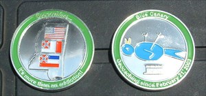
The reverse of the coin has an outline of the State of Mississippi and three flags. Mississippi was admitted to the Union on December 10, 1817. On January 9, 1861 it seceded from the Union and was admitted to the Confederate States of America on March 27, 1861. On February 23, 1870 it was readmitted to the Union. The three flags are the current flags of the United States of America and the State of Mississippi and the last official flag of the Confederate States of America. The obverse of the coin has the logo of Blue Canary, who has been geocaching since February 21, 2003. A blue canary is a term used only half in jest by firemen in referring to law enforcement officers at a hazardous materials incident. Unfortunately, Hazmat training for law enforcement has lagged behind that of fire fighters. Law enforcement is usually trained to rush immediately to any incident they are called to. Fire fighters have been trained to observe the area as they approach. Only half jokingly fire fighters are taught in responding to hazardous material incidents to observe any law enforcement officers already on the scene to see if the "Blue Canaries" appear OK or are prone on the ground. Blue Canary is a retired law enforcement officer
Gallery Images related to Blue Canary Geocoin #9 - Pacific States
View All 6 Gallery Images
Tracking History (10735.6mi) View Map
|
MulderClan! took it to 3.14.15 9:26:53 aka Pie Potluck in the Park
|
British Columbia, Canada
- 1.67 miles
|
Visit Log
|
|
|
|
MulderClan! took it to Graffiti Tunnel
|
British Columbia, Canada
- 2.71 miles
|
Visit Log
|
|
|
|
MulderClan! took it to That's a hard pill to swallow
|
British Columbia, Canada
- 6.43 miles
|
Visit Log
|
|
|
|
MulderClan! took it to Fields of Flowers
|
British Columbia, Canada
- 11.32 miles
|
Visit Log
|
|
|
|
MulderClan! took it to NSWF #4 -American Coot
|
British Columbia, Canada
- 14.76 miles
|
Visit Log
|
|
|
|
MulderClan! took it to Upper Fishtrap Lake
|
British Columbia, Canada
- 4.83 miles
|
Visit Log
|
|
|
|
MulderClan! took it to Eagle Mountain has nice views
|
British Columbia, Canada
- 31.78 miles
|
Visit Log
|
|
|
|
MulderClan! took it to rocky riddle rambles - historic tongue twister
|
British Columbia, Canada
- 32.47 miles
|
Visit Log
|
|
|
|
MulderClan! took it to Stumpile
|
British Columbia, Canada
- 7.33 miles
|
Visit Log
|
|
|
|
MulderClan! took it to Old Harper's Country Market
|
British Columbia, Canada
- 7.54 miles
|
Visit Log
|
|
|
|
data on this page is cached for 3 mins
|