
This cache is one of a trilogy of EarthCaches introducing three of the great landowning families of the late 18th and early 19th Centuries in Mid-Cornwall. The Treffrys, the Rashleighs and the Hawkins. They each played an enormous part in the development of mining in Cornwall and in particular the development of transport links in South Cornwall. They also left their mark on the Mid-Cornwall coastline with the development of Newquay, Par, Charlestown and Pentewan Harbours.
The other EarthCaches in the series are 'Cornwall's Mining Heritage - Luxulyan Valley'(GC116DV) and 'Cornwall's Mining Heritage - Charlestown Harbour' (GC1199G)
Pentewan has for many centuries been a fishing and commercial port, with a small harbour at the mouth of the St. Austell River, the first artificial port being constructed in 1744. With the development of tin, copper and clay mining in the Mid-Cornwall area, the landowning mining entrepreneurs of the area each developed their own transport and shipping facilities, with considerable rivalry. The Treffrys developed Par and Fowey Harbours, the Rashleighs, Charlestown and the Hawkins developed a railway from St Austell to Pentewan and a new harbour at Pentewan.
Christopher Hawkins of Trewithen (1758-1829) commissioned a four mile long, narrow gauge, horse drawn tramway from St. Austell which opened in 1829. The harbour at Pentewan was developed to include a dock basin, controlled by gates, between 1817 and 1824, finally opening to trade in 1826.
Although by 1855 Pentewan was the fourth largest in terms of clay shipping, the harbour had a continuing problem with silting. Much of the material which caused the silting was brought by the St. Austell river. This river, during the 19th and 20th centuries, was (and still is by locals) known as the ‘White River’, due to its milk like appearance, caused by kaolin (china clay) particles carried in suspension from the clay works around St. Austell. The clay running out into the sea also gave the sea a distinctive turquoise/blue colour which can be seen on old postcards and photographs of Pentewan.
The tramway, although freight only, did have one passenger carriage which was reserved for the Hawkins family. In 1874 the well-known railway engineer, John Barraclough Fell, (inventor of the Fell mountain railway system) converted the line to steam locomotive working. The line continued in use until 1916. Part of the railway around the harbour was later rebuilt and reopened to serve a sand extraction and block making works and finally closed in 1966. The original track bed now forms the basis of part of the cycle/walking track from St. Austell, “The Pentewan Trail”. The track remaining around the harbour is part of the sand works track.
The dock /harbour was used to export clay, tin ore and copper ore and import limestone, coal, wood, salt and grain until 1929 and continued to be used to export sand and blocks until 1940 when the last ship sailed from the dock carrying 300 tons of sand. After the Second World War new gates were fitted to the basin and the channel dredged but no commercial ships returned to Pentewan, just a few pleasure craft. The 400 yard channel to the sea began to silt up again, isolating the water in the dock behind the gates, forming the tranquil haven for wildlife that exists today. Pentewan is a splendid example of how natural forces defy man’s best efforts!
To log this EarthCache you must visit Pentewan. You are required to take a photograph of (your GPSr or yourself with) some part of the harbour or with the village pump in the background (if you cannot provide a photograph the waypoint for the village pump (+/- 0.005’) will be accepted.
Then answer the questions below and email your answers to me using this link or via the profile.
New EarthCache guidelines 2010
Under the new guidelines, a photograph can be requested but specific detail cannot be required. Consequently your photograph can be just a general photo of the site. However a personal touch such as your GPSr (or yourself/member of your team!) in the photo makes it much more interesting. To log this cache you may submit the co-ordinates for the ‘Village Pump’ instead of a photograph, as stated in the notes, but a photograph will eliminate the need for this measurement (and the risk of being outside the +/- .005’ limits)
Please email me your answers and then log the cache and include your photograph. I will review your answers and if there is any problem I will contact you to agree a course of action.
Question A) Waypoint P1 N50° 17.463’ W004° 46.892’
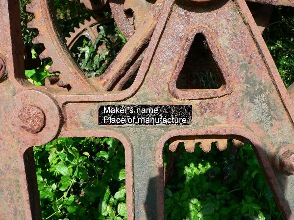
Question A) At this waypoint, near the dock basin gates you will find a cast iron windlass (winch), which was used to open and close the dock gates. Cast into the frame is the name and location of the maker. What are they?
Question B) Waypoint N50° 17.442’ W004° 46.869’
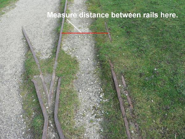
Question B) At this waypoint you will find some of the narrow gauge railway track. What is the gauge (distance between the rails) in inches? You are advised to take the measurement as shown on the photo rather than at the points.
Question C) Waypoint N50° 17.455’ W004° 46.890’
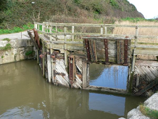
Question C) The waypoint given is for the dock basin gates, using this waypoint, walk to the Northwestern end of the dock (near the railway weighbridge and car park) and record the distance to the waypoint. This will correspond to the length of the dock. What is the length of the dock created by Hawkins to export his ore and clay? 