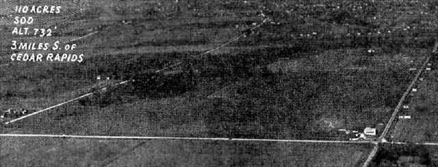
An undated aerial view of the original Cedar Cedar Rapids Municipal Airport, from The Airport Directory Company's 1933 Airport Directory (courtesy of Chris Kennedy).
This cache is located near a plaque commemorating the location of the Hunter Field.
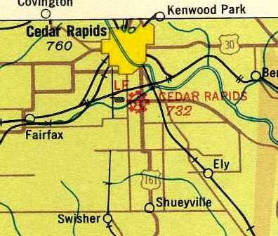
The first Cedar Rapids Airport was located 3 miles south of the center of the town,on the west side of the main north/south highway. According to the Linn County Historical Society, when military pilot Dan Hunter came home to Cedar Rapids from the First World War, he was determined to launch a career as a civilian pilot. However, Cedar Rapids lacked an airport. Hunter acquired a surplus warplane and spent the early 1920s as a stunt flyer, operating Hunter’s Flying Circus from a pasture In 1924, he moved his one-man aviation service to farmland just north of Highway 30.
Hunter rented the property from the Chamber of Commerce (& later the City of Cedar Rapids) and ran the airport under the name of Cedar Rapids Airways. The airport had a dirt runway that was relatively short & lined by trees, so its early use was limited by weather conditions & the availability of daylight. Despite the field’s drawbacks, Boeing Air Transport, which later merged into United Airlines, signed up to route its new air mail service through Cedar Rapids, with the first flight arriving on July 10, 1928. Passengers could ride in cramped quarters (with the mail) to Chicago for the princely sum of $21, provided they brought their own lunch, thermos, and cotton for their ears.
The earliest depiction which has been located of the original Cedar Cedar Rapids Municipal Airport was in The Airport Directory Company's 1933 Airport Directory (courtesy of Chris Kennedy). It described Cedar Rapids as a commercial airport, consisting of a 110-acre triangular sod field, measuring 2,640' x 2,200' x 2,800'. The photo depicted the field simply as an open grass field, with a hangar in the southeast corner (which was said to have “Cedar Rapids Airport” painted on the roof). The operator was listed as Cedar Rapids Airways Inc., and the manager was listed as D.F. Hunter.

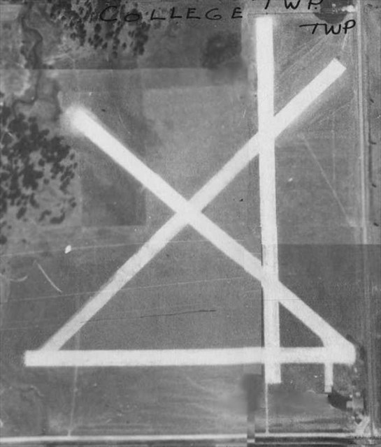
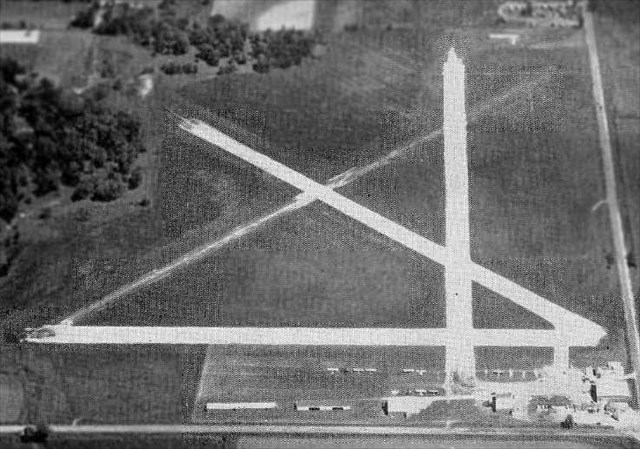
An undated (circa 1930s?) aerial view looking northeast at Hunter Field, from a historical display inside the Cedar Rapids Municipal Airport (2006 photo by Paul Freeman). The field was depicted as having 4 unpaved runways, with a cluster of buildings in the southeast corner.
Dan Hunter, local businessmen, and the city gradually made improvements to the field, with service sometimes being cut off for a time as upgrades were made to accommodate newer, larger planes.
The earliest chart depiction which has been located of the original Cedar Cedar Rapids Municipal Airport was on the June 1937 Des Moines Sectional Chart (courtesy of Chris Kennedy). It depicted Cedar Rapids as a commercial/municipal field.
The Airport Directory Company's 1937 Airport Directory (courtesy of Bob Rambo) described Cedar Rapids Municipal as consisting of a 140-acre irregularly-shaped sod field, having 4 crushed-rock runways, with the longest being a 2,000' northeast/southwest strip.
A 1937-39 USDA aerial photo of Cedar Rapids Municipal Airport (from the IA Geographic Map Server, via Chris Kennedy).It depicted the field as having 4 runways, with a small cluster of buildings on the southeast side of the field.
In 1939, Jim Wathan, a former student of Dan Hunter, went to work for Hunter as a flight instructor.
The Airport Directory Company's 1939 Airport Directory (courtesy of Chris Kennedy) described Cedar Rapids Municipal as consisting of a 140-acre irregularly-shaped sod field, having 4 crushed-rock runways, with the longest being a 2,250' northwest/southeast strip.
In the late 1930s, as the specter of war grew, the government stepped up its efforts to train civilian pilots, and Cedar Rapids Municipal was used for this purpose. When war broke out, the field served as a base for a War Training Service pilot program at Coe College that was one of the largest in the Midwest. At one time, there were as many as 70 instructors & 300 students in the program.

Colonel Dan Hunter
Hunter Field was named one of three Iowa locations for the CPTP Advanced Training Center providing cross-country and flight-instructor training. Colonel Dan Hunter also commander Iowa's Wing of the Civil Air Patrol.

This photograph was taken of Hunter Field sometime during World War II. A Lockheed P-38 Lightning is visible in the upper left-hand corner. (Courtesy of the Carl and Mary Koehler History Center, Linn County Historical Society.)
Christopher Hall recalled, “My grandfather, Harold Hall, was a flight instructor at Hunter Field during & after WWII.”
In 1944, Wathan & Hunter went into business together, forming a partnership that lasted until 1952.
At some point between 1937-44, the airport was evidently renamed Hunter Field, as that is how it was labeled on the March 1944 Des Moines Sectional Chart (courtesy of Chris Kennedy).
After the war, former soldiers, taking advantage of the G. I. Bill, flocked in droves to flight training at Cedar Rapids Municipal Airport. Due to limitations when conducting flight operations in bad weather at the relatively small Hunter Field, a larger Cedar Rapids Airport was established in 1947 a few miles to the southwest. But Hunter Field continued to operate as a general aviation airport for at least another decade.
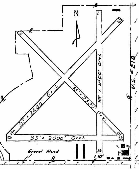
The 1948 Iowa Airport Directory (courtesy of Chris Kennedy) depicted Hunter Field as having 4 gravel & turf runways, with the longest being the 2,640' Runway 4/22. Buildings were depicted on the south & southeast sides of the field. The field was said to offer repairs, hangars, tiedowns, flight instruction, and charter. The operator was listed as Hunter Flying Service Inc., and the manager was listed as Jim Wathan.
Christopher Hall recalled, “My grandfather, Harold Hall... went to work for Jim Wathan as Vice President of Wathan Flying Service sometime in the 1950s.”
An undated aerial photo looking north at Hunter Field, from the 1952 Iowa Airport Directory (courtesy of Chris Kennedy). It depicted several light planes along the south side of the field. It described the field as having 4 gravel runways, with the longest being the 2,700' northeast/southwest strip. The operator was listed as Hunter Flying Service Inc., and the manager was listed as Jim Wathan.
The last depiction which has been located of the original Cedar Cedar Rapids Municipal Airport was on the June 1955 Des Moines Sectional Chart (courtesy of Chris Kennedy). It depicted Hunter Field as having a 2,700' unpaved runway.
The last directory listing which has been located of Hunter Field was in the 1957-58 Aviation Week Airport Directory (according to Chris Kennedy).
Dan Hunter retired in 1958 & sold his land for industrial development.
Hunter Field no longer depicted on the June 1959 Des Moines Sectional Chart (according to Chris Kennedy).
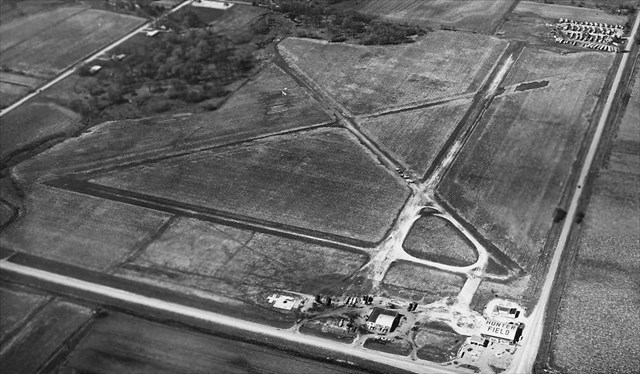
An undated (circa 1950s?) aerial photo looking northwest at Hunter Field (courtesy of Matthew Jangelis).
A hangar was painted with “Hunter Field” on its roof, but there were no aircraft visible on the field, and at least one building had been removed, so possibly this photo was after the airport had already closed.
A circa 1964 aerial view of the site of Hunter Field (courtesy of Tom Farland). Tom observed, “Some of the airfield buildings still remained - at the time, I recall you could still make out the word 'HUNTER' on the roof of the hangar. The runways were still visible to a certain extent.CRANDIC Railway spur had been run down from the north & the first factory was under construction.”
Hunter Field no longer depicted on the 1967 USGS topo map.
As of 2003, the site of Hunter Field was occupied by Midland Forge & the Gazette Printing Plant (according to the Linn County Historical Society).

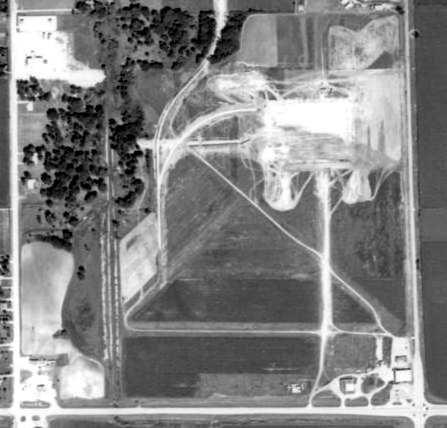
The alignment of the 4 runways from Hunter Field were superimposed by Chris Kennedy over a 2006 aerial view of the site of the airport.
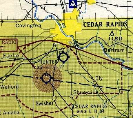
The site of Hunter Field is located northwest of the intersection of Highway 30 & Bowling Street SW.

Aviation Caches
Aviation Cache: A-7D Corsair II 71-0213
Aviation Cache: A-7D Corsair II 71-0334
Aviation Cache: A-7D Corsair II 71-0254
Aviation Cache: And Then There Were Three
Aviation Cache: AH-1 Cobra
Aviation Cache: Ames Municipal / Wearth Airport
Aviation Cache: B-17F 42-30535
Aviation Cache: B-17G 42-97224
Aviation Cache: B-24 41-29052 Crash Site
Aviation Cache: The Cyclone Post
Aviation Cache: F-86L Sabre 53-0750
Aviation Cache: Aviation Cache: F-80 Midair Collision 10/22/1954
Aviation Cache: Hap Westbrook
Aviation Cache: Hunter Field
Aviation Cache: I Hear The Choppers Coming
Aviation Cache: Lamotte Air Defense Radar Station
Aviation Cache: MERLE
Aviation Cache: Morningstar Field / North Field
Aviation Cache: NAS Ottumwa
Aviation Cache: NAS Ottumwa Auxiliary Airfield #10
Aviation Cache: The Parakeet Casualty
Aviation Cache: Phantom
Aviation Cache: Scorpion Down - December 9, 1968
Aviation Cache: The Silent Knights
Aviation Cache: T-33 Shooting Star 51-4406
Aviation Cache: T-33 Shooting Star 53-5916
Aviation Cache: T-33 Shooting Star 58-0579
Aviation Cache: Thunderflash
Aviation Cache: Thunderstreak
Aviation Cache: The Vantage