When I go to a new biking area, it's always SO helpful to me when I know parking & trailhead info, and what trails are available, and how far the bike rides are for all the trails. I got to thinking that other people would be grateful for this valuable information also, so I've decided to create some caches that will help others, like it does me. I am going to publish a series of caches with all the information that I can find to help bikers to make informative decisions. I hope these caches help you. Please take into account that the rated difficulty levels of these trails are subjective!
If you do not have an Idaho State Parks pass there is a $5 day fee, unless you are camping at the campground. Stop at the Visitor Center, regardless, to pick up a park map and inquire on trails. I have included pictures of the hiking trail routes in the gallery.
Container is a 30-cal ammo can.
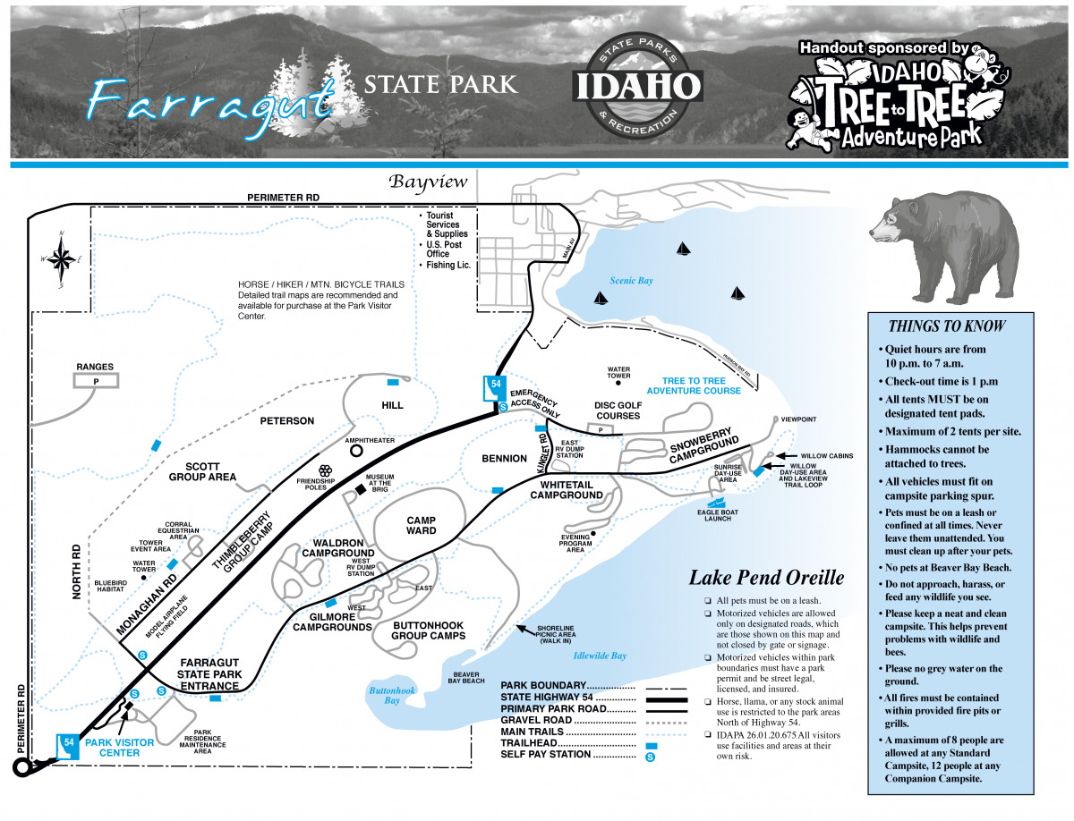
FARRAGUT STATE PARK INFO:
Located on the southern tip of Lake Pend Oreille in the mountains of northern Idaho, 4,000-acre Farragut State Park offers beautiful scenery, history and an abundance of recreational opportunities, including disc golf, radio-controlled airplane field, fishing, hiking, biking, swimming, boating, camping, equestrian facilities and even World War II history as the world's second largest naval training base - don't miss the Museum at the Brig during your visit. In winter, it is a premier cross-country skiing and snowshoeing destination. For boaters there is a launch ramp and docks. New to the park is the Tree to Tree Adventure Park.
Farragut Recreation Trail (outside the park boundary)is a 4-mile trail that parallels highway 54 from the freeway to the park, and ends at the park fence, where you can walk or bike right into Farragut. It is totally flat, with forest on both sides of the trail. There is some private property lining the trail, so please don't stray far, not that you would want to. This trail is wonderful for all ages, and is a great biking trail and x-c ski trail. There is a trail of geocaches along it for your geocaching pleasure.
Closest coords to park, on Perimeter Rd: N 47* 57.104 W 116* 36.787
Next, on Caravelle Rd: N 47* 57.099 W 116* 37.214
Next, on Red Fir Rd: N 47* 57.089 W 116* 39.332
Howard Rd: N 47* 57.084 W 116* 41.191
Roberts Rd, by Super 1 (3.71 miles) N 47* 57.086 W 116* 41.587
Highpoint Trail is a bit more strenuous three-mile ride (six round-trip) as the destination is Bernard Peak with excellent viewpoints of the south end of 43-mle-long Lake Pend Oreille. It is easy for the first two miles, then rocky and steep for the final mile. It is rated moderate difficulty overall.
Coords for this trail parking are the same as Scout Trail to Bernard Peak. Park at: N 47° 57.117' W 116° 35.548'
Scout Trail to Bernard Peak is a 16.7 mile moderately trafficked out and back trail and is rated as difficult. Coords for this trail parking are the same as Highpoint Trail.
Park at: N 47° 57.117' W 116° 35.548'
Lynx Trail is a moderate 6-mile loop trail. The trail is primarily used for hiking, walking, running, and mountain biking. This trail joins many other trails along the South Road. I believe it starts at the Visitor Center and goes through many campgrounds and hiking trails, and can be found at Whitetail Campground, etc. There are many access points.
Shoreline Trail winds along Buttonhook Bay with outstanding views of the Monarch Mountains surrounding the very scenic bay. It’s an easy ride, 1.5 miles one way. There is a nice picnic area along the way, and it also has access to the Amphitheater that is in Whitetail Campground. The higher part of the loop is wide and flat, and more suitable for smaller children or new bikers.
West and East Trailhead coords are: N47° 57.353' W116° 34.001' (Swim Area) N47° 57.900' W116° 32.914' (Boat Launch)
Willow Lake View Loop Trail is a 1-mile loop between the boat launch and Sunrise Day Use Area This is a very popular family hiking trail, so during the busy season you will have to dodge many hikers. You can park at the boat launch or at the Day Use Area.
Coords are: N47° 57.915' W116° 32.703' (boat launch) N47° 58.034' W116° 32.473' (Sunrise Day Use Area)
Farragut Loop Trail, is a moderate 14.5-mile loop around the exterior edge of the park. Great for mt biking.
Buggy Trail Loop is a moderate 8.2-mile loop around the edge of the park. There are many access points. I read that clockwise is recommended, but I'm not sure why.
The Northside Loop Trail is a 7.6-mile loop around the edge of the park. There are many access points. It's basically the Buggy Trail Loop with a cutoff that cuts just over 1/2-mile off the trail.
Squirrel Cache Nature Trail is a 1.2-mile loop with interpretive signs and meadow and forest habitats.
Coordinates for the trailhead are: N 47° 57.487 W 116° 34.991
Bennion Historical Trail is an easy 1.4 mile out and back trail and is good for all skill levels, including very small children. Watch out for flying frisbees! This trail is on the edge of part of the disc golf course. You can park at either end.
Parking coords are: N 47° 57.918' W116° 34.017' (South Road) N47° 58.161' W116° 33.744' (Crossover Road)
The trails and many roads in the park are suitable for hikers as well, and some of the trails are open for horseback riding. If they are open for this, they are marked.
HISTORY OF FARRAGUT STATE PARK:
Ground was broken in March 1942, and by September the base had a population of 55,000, making it the largest city in Idaho. Liberty trains to Spokane ran three times daily. At the time Farragut was the second-largest naval training center in the world.
During the 30 months the base was open, 293,381 sailors received basic training at Farragut. The last recruit graduated in March 1945 and the facility was decommissioned in June 1946.
From 1946-49 it was the site of the Farragut College and Technical Institute, which did not re-open in late 1949 due to financial difficulties. The park adjoins the deepwater Lake Pend Oreille, where the Navy maintains a submarine research center at Bayview, the Acoustic Research Detachment. The land was transferred to the state of Idaho in 1949 and became a state park in 1965.
OTHER POINTS OF INTEREST:
The Disc Golf Course area is huge and actually has 3 separate courses, but the main parking lot & restroom are at: N 47° 58.169' W 116° 33.551'
The Museum is very interesting. It can be accessed by the South Road/Ward Loop and the parking coords are: N 47° 57.915' W 116° 34.845'
Tree to Tree Adventure Park is past the Disc Golf parking lot and the general coords are: N 47° 58.152' W 116° 33.279'
Shooting Range is located at: N 47° 58.400' W 116° 36.389' It's always seemed kinda strange to me to have a shooting range in a state park/campground. I don't know much about this part of the park. I believe that there is an entrance off Perimeter Road.
MY OTHER BIKE TRAIL CACHES:
Fish Lake Trail
Hiawatha Trail
Centennial Trail
Trail of the Coeur d'Alenes
Athol/Coeur d'Alene Bike Path
Columbia Plateau Trail
Palouse to Cascades Trail
Beacon Hill
Children of the Sun
Ed Corkill Memorial Trail
Bill Chipman Trail
Latah Trail