The Columbia Plateau Trail is a 130-mile-long, 20-foot-wide corridor in eastern Washington state maintained as part of the Washington State Park system. The trail runs along the abandoned right-of-way of the former Spokane, Portland and Seattle Railway from Cheney to the confluence of the Snake and Columbia rivers at Pasco, Washington, passing through five counties in the southeastern part of the state.
The rail bed was constructed by the Spokane, Portland, and Seattle Railway Company in the early 1900s. That line's successor, the Burlington Northern Company, abandoned the line in 1987, paving the way for the state to acquire 130 miles of right-of-way, from milepost 235.0 near East Pasco to milepost 365.0 near South Cheney, in 1991. State Park management began in 1992.
Columbia Plateau is part of State Parks' commitment to long-distance recreation trails, and long-range plans include developing trail through Devil's Canyon to Benge, with segments along the Palouse River and a connection to Sacajawea State Park. Currently, 23 miles of the trail between Lincoln County and Cheney and 15 miles in Franklin County are developed and open for public use.
The trail area has an amazing geologic story to tell. Huge outpourings of basaltic lava about 15 million years ago buried the eastern Washington landscape under a sea of lava. Much later, during the Ice Age (and as recently as 13,000 years ago), some of the largest documented floods of water to ever occur raced across eastern Washington, carving out a landscape of basalt buttes, basins and canyons. A volume of water comparable to some of today's Great Lakes was unleashed when an ice dam in northern Idaho burst. Dozens and perhaps hundreds of flood events eroded the lava surface into the unique landscape known as the channeled scabland. Trail visitors will see stark reminders of one of the world's largest volcanic fields eroded by the cataclysmic Ice Age floods.
The drive out here is beautiful! I thoroughly enjoyed my drive out here to place the cache. The Scablands had beautiful tones of green grass right now, and there were lots of wildflowers and beautiful Bachelor's Buttons blooming. This is definitely a great time to drive out here!
Go Prepared
Planning is key to an enjoyable day trip along the Columbia Plateau Trail. Part of the appeal of this unique trail is that it offers a break from the hustle and bustle of every day life and an opportunity to enjoy the wide open spaces of eastern Washington.
Crossroads are rare. Public facilities are scarce and summer temperatures often exceed 100 degrees Fahrenheit. The trail also features 18 railroad trestles, all of which offer interesting viewing but lack decking and guard rails (most are closed to use). Trail users should carry the 10 essentials: extra food and water, maps, a compass, flashlight, sunglasses, first-aid kit, pocket knife, waterproof matches and a fire starter. Travelers may need other supplies as well, depending on the length of their trek. Beware of car theft, and do not leave valuables in your car.
NORTH END:
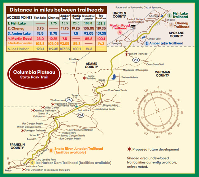
This trail is still in the making. It could eventually go from Spokane to Tri-Cities, a 130-mile ride, but it's not there yet. Right now the old railroad bed on the north end is only improved for 23 miles, not counting the 10.4 miles of Fish Lake Trail that it joins with. The Fish Lake Trail starts in Spokane and ends at Fish Lake. Where the Fish Lake Trail ends, the Columbia Plateau Trail begins. Right now, though, this trail is only paved the first 3.75 miles, from Fish Lake to Cheney. The remaining 19.25 miles have a crushed-rock trail surface and are useable by horseback riders, mountain bikers and hikers. It would be a wonderful thing if they paved it! The trail passes through 4.75 miles of Turnbull National Wildlife Refuge, home to deer, elk, moose, small mammals and 200 species of birds. (The best times to visit are early morning and evening.) Between March and May, and September and November, you'll be treated to spring and fall bird migrations; you may even see a trumpeter swan. The 23-mile improved trail provides rest and swim stops at Cheney and Amber Lake and ends at Martin Road. Most hikers arrange for an overnight stay or a car shuttle.
Getting there:
On the north end, from Cheney, take Cheney-Spangle road to get to the Cheney trailhead, and take S Mullinex Road from Cheney to get to Amber Lake and Martin Road trailheads. Follow the signs. Directional signs to trailheads are provided on I-90, state routes and county roads.
SOUTH END:
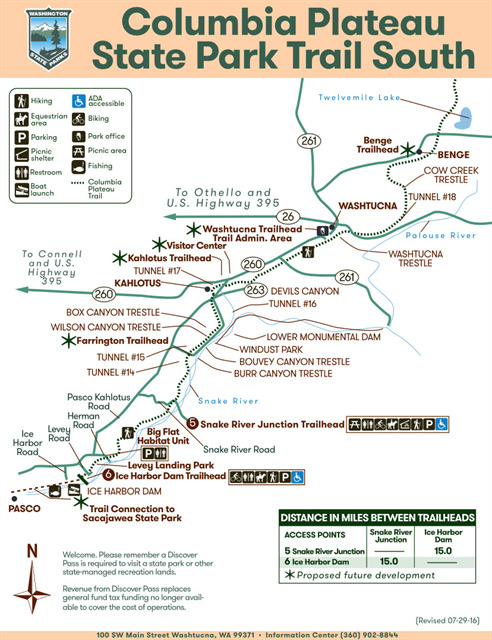
The southern end of the trail overlays the former Spokane, Portland and Seattle Railroad opened in 1908. The trail follows the Snake River from the impressive Ice Harbor Dam to the Snake River Junction 15 miles north. This section made of crushed gravel welcomes walkers, bikers and equestrians. The trail has several U.S. Army Corps of Engineers access points.
Getting there: Snake River Junction Trailhead
Southbound 395 to 182 to Highway 12: Take Kahlotus exit and drive northeast on the Pasco/Kahlotus Highway. Travel approximately 23.5 miles to Snake River Road. Turn right, and drive 4.6 miles to Lake Sacajawea and Snake River Junction Trailhead.
Getting there: Ice Harbor Dam Trailhead
Southbound 395 to 182 to Highway 12:Take Kahlotus exit and drive northeast on the Pasco/Kahlotus Highway. Travel approximately 9.9 miles to Ice Harbor Dam Road. Turn right, and drive three miles. Make a left turn just before road onto the dam. It is .3 miles to trailhead from this point.Parking (including equestrian units), restroom,informational kiosk and boat launch
UNDEVELOPED MIDDLE SECTION:
The trail's nearly 100-mile midsection remains undeveloped and goes for long stretches without resources such as food supplies, potable water and first aid. It is only recommended for expert long-distance hikers who undertake careful planning.
INFO:
A Discover Pass is required for vehicle access to state parks for day use. For more information about the Discover Pass and exemptions, please visit the Discover Pass web page.
As usual, it is not a good idea to leave valuables in your car.
This is a park n grab cache. Attributes are mostly for the trail itself.
HOURS:
6:30 a.m. - dusk year round
USES:
Biking, hiking, wildlife viewing, cross-country skiing, snowshoeing, inline skating, horseback riding
TRAIL CONTACT INFO:
Columbia Plateau Trail State Park South (main) Office
100 S.W. Main St.
P.O. Box 541
Washtucna, WA 99371
(509) 646-9218
Riverside State Park (north portion only)
9711 W. Charles Road
Nine Mile Falls, WA 99026
(509) 465-5064
ACCESS POINTS:
Proceeding from the northeast toward the southwest, major access points include:
FISH LAKE TRAILHEAD:N 47 31.333 W 117 30.943 START OF TRAIL
Vault toilet, Covered ADA accessible picnic tables , paved parking lot, informational kiosk, swim opportunity (not sure about a life guard)
CHENEY TRAILHEAD: N 47 28.772 W 117 33.616
2 vault toilets, 2 Covered ADA accessible picnic shelters, large paved parking lot (including equestrian units), informational kiosk
Trail is paved to Cheney trailhead. Beyond this trailhead the trail turns to crushed gravel.
AMBER LAKE TRAILHEAD: N 47 20.921 W 117 42.899
vault toilet, boat launch, large UNpaved parking lot (including equestrian units), equestrian highline, informational kiosk, swim opportunity (no life guard)
MARTIN ROAD TRAILHEAD: N 47 17.032 W 117 49.776 END OF NORTH SECTION OF TRAIL
vault toilet, large UNpaved parking lot (including equestrian units), equestrian highline, informational kiosk.
SNAKE RIVER JUNCTION TRAILHEAD: N 46 23.393 W 118 40.842
restroom, Covered ADA accessible picnic tables, parking (including equestrian units), information kiosk, handicap accessible
ICE HARBOR DAM TRAILHEAD: N 46 15.181 W 118 52.705
restroom, parking (including equestrian units), handicap accessible, informational kiosk and boat launch
Lamont Trailhead
PROPOSED FUTURE DEVELOPMENT
John Wayne Pioneer Trail intersection (no trailhead)
Benge Trailhead
PROPOSED FUTURE DEVELOPMENT
Washtucna Trailhead (Trail Administrative Area in downtown Washtucna)
PROPOSED FUTURE DEVELOPMENT
Kahlotus Trailhead & Visitor Center
PROPOSED FUTURE DEVELOPMENT
Farrington Trailhead
PROPOSED FUTURE DEVELOPMENT
Sacajawea State Park Pasco
PROPOSED FUTURE DEVELOPMENT
MY OTHER BIKE TRAIL CACHES:
Fish Lake Trail
Hiawatha Trail
Centennial Trail
Farragut State Park
Trail of the Coeur d'Alenes
Athol/Coeur d'Alene Bike Path
Beacon Hill
Palouse to Cascades Trail
Children of the Sun
Ed Corkill Memorial Trail
Bill Chipman Trail
Latah Trail