
Piz Palü 3901 m.ü.M. — Geocache of the Week


- Traditional
- GC5B9WM
- by the Schnuppels
- Location:
- In Graubuenden (GR), Switzerland
- N 46° 22.715′ E 009° 58.152′
“Thousands of tired, nerve shaken, over-civilized people are beginning to find out going to the mountains is going home.” –John Muir

If you love extreme, you’ll love this GOTW. In Switzerland, a mountain cache sits at 3,901 m (12,800 ft). Home to 30,239 active geocaches, and more than 250 summits above 3,600 m, Switzerland is a haven for mountain caching. According to the cache owner, Piz Palü is one of the great treasures of the Alps. “You will experience here breathtaking views that you will never forget, because you have to earn it with endurance and skill. The entrance over the Pers glacier is only possible with crampons, pick axes, and ropes.” –the Schnuppels

The journey can be split up into 3 days per Cosley & Houston’s Alpine Guide.
Day 1
Start by riding the Diavolezza lift to almost 3,000 m. From here you descend to the Pers Glacier, cross this and ascend the Fortezza to the Bellavista Terraces. These are followed to the Marco e Rosa hut, 3,597 m, where you spend the night.

Day 2
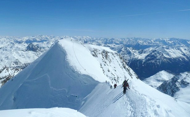
From the hut you climb up first glacier, then steeper snow, and finally rock to gain the east ridge of the Spedela, a 4020 meter sub-peak of the Bernina. From here a narrow ridge crest sometimes rock, sometimes snow, leads to the airy summit. Follow the same route back to the hut to spend a second night.

Day 3
On our last day, traverse back across the Bellavista Terraces to the pass at the west end of the three summits of Piz Palü. The first summit is mostly rock. the second and third are snow, with some steep and narrow snow ridges to add spice to the adventure. After descending the large Vedret Pers glacier, climb back to the Diavolezza lift and take it back to the valley.
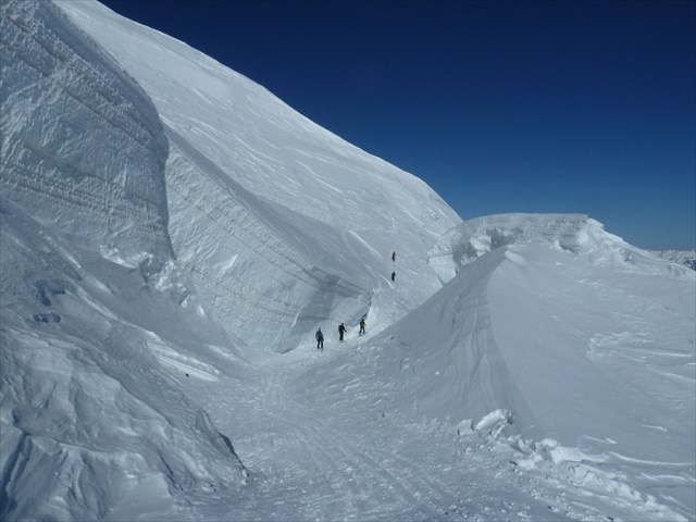
The descent is steep and can be dangerous. Temperatures in the region can hit -22 degrees celsius at night (uh brrr?) and the cache page says the initial ascent of the mountain is 5-6 hours — the descent about 4 hours. Geocachers are drawn to parts of the Earth like this to fight nerves and be in an environment where they feel at home. Spending three days to earn a geocache through blistering freezing temperatures, putting your faith into your pickaxe on the side of a cliff hundreds of meters in the air, and getting swept in all directions by the Apline wind is home to some. Call it crazy, call it geocaching, call it what you will, it’s all in the spirit of adventure and finding your happy place in the world.
“At 4:40 we started from the Diavolezza. Apart from the ascent on the previous day, the first day on the route was exhausting, even without the acclimation. But in the end, we had a good time on the saddle and could fill up the summit with a short break. We were able to get here without a rope, so it was no problem to quickly go to the memorial plaque. I was surprised at how wide the saddle is.
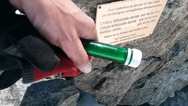
Thanks so much for the cache at this special place! This was, of course, the icing on the cake! Now I’m curious when I’ll find an even higher cache. For a while, this cache will probably remain on place 1 of my high altitude list.” –SteinbamOne 6th log entry.

The Schnuppels was the pioneer who placed this extreme cache, and only 8 others have braved the journey since 2014.
